
You're here: MiBSAR's home page :: Essential SAR bush gear index page :: Land nav bush gear page
Michigan Backcountry
Search and Rescue (MiBSAR)
Essential land nav gear primer
By
Michael Neiger
Marquette, Michigan
© Copyright 2008
Page contents
•
Baseplate compass
•
Baseplate compass modifications
• Land nav crib
card (rev 09-19-08)
• Topographic map
preparation
• U.S. Army
Ranger pacing beads
• Heavy-duty
wrist compass
•
Pencil and
paper
•
GPS units
I can’t
rightly say I’ve ever been lost,
but I’ve been mighty perplexed for two or three days runnin'.
—Davy Crockett (1786-1836)
To more efficiently and effectively calculate and cut azimuths while bushwhacking—hour after hour, day after day—consider one or more of the following ideas, which have proved useful on prior remote, long-range, multi-day trips, expeditions, and SAR ops.
Top
of page
Baseplate compass
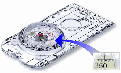
A high-quality, name-brand baseplate compass—such as the Brunton 54 pictured below—is essential for long-range land nav ops, especially those conducted off trail. The longer the base, the better.
Suppliers of the Brunton 54 baseplate compass pictured above—with its one-of-kind optical sighting mechanism accurate to 0.5 degrees—include The Compass Store. NATO tritium (compound 20 mCi) night-vision models are available from Wellington Surplus Stores (Australia) and The Outdoorsman Limited (United Kingdom). More compass manufacturers and vendors.
Look at this vigorous plant
that lifts its head from the meadow,
see how its leaves are turned to the north,
as true as the magnet;
this is the compass-flower,
that the finger of god
has planted here in the houseless wild,
to direct the traveler's journey.
—Henry W. Longfellow (1807-1882),
Evangeline, 1847
Top
of page
Baseplate compass
modifications
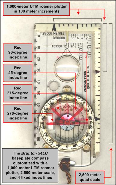
Compass-mounted UTM roamer scale
Baseplate-mounted roamer scales make quick, on-the-go, calculation or plotting of UTM coordinates very easy. If you don't have a two-dimensional roamer scale on your baseplate compass, consider adding one (see annotated photograph below).
Fold pieces of 1/2-wide, white, first-aid tape over the front edge and the right-hand edge of your baseplate compass (held in front of you, viewed from above, with the business end pointed away from you). The tape should be folded equally along the bottom and top of the compass, and one end of both pieces should meet at a common corner, the right front corner.
Next, using an indelible marker or write-in-the-rain pen, lay the top edge of the compass up against the kilometer scale on your topographic map (you will have to change the scale on your compass if you use different scale maps on different trips) and simply transfer the 100-meter hash marks onto the tape on the top side of your baseplate, starting at the common corner, until you have plotted 1,000 meters worth. Do the same along the right edge of your compass.
Compass-mounted map scale
Baseplate-mounted map scales make quick, on-the-go, calculation or plotting of linear distances very easy. If you don't have a one-dimensional map scale on your baseplate compass, consider adding one (see annotated photograph above).
Holding the right edge of your compass against the kilometer scale on your map, continue marking hash marks beyond the 1,000 meter mark that you marked off for the UTM roamer scale above. Mark as many as you can, hopefully to the 2,000 or 2,500-meter interval. To make them easier to see, make the 1,000 meter interval tick marks extra dark.
To keep the hash marks from rubbing off from wear and tear, sweat, rain, river water, or DEET, cover the 100-meter hash marks on the first-aid tape with clear scotch tape.
Looped lanyard attached to compass
Make sure your compass has a looped lanyard so you can hang it around your neck, or attach it to a lanyard loop in a shirt pocket or compass pouch on the shoulder strap of your rucksack (see annotated photograph above).
It should be long enough so you can hold it comfortably in your hand while calculating an azimuth on a map or cutting an azimuth in the bush. The lanyard should be long enough so you can quickly stow it in a secure but easily accessible location—without unfastening the lanyard—to prevent damage while bushwhacking or climbing. Some manufacturer-provided lanyards are a bit short for regular use while underway in the bush.
Fixed index lines on compass bezel
If you have scribed fixed index lines at the 45-, 90-, 270-, and 315-degree intercardinal points on the rotating bezel of your baseplate and wrist compasses, consider refreshing them with a few coats of red indelible ink from a Sandford Sharpie permanent marker.
If your compass lacks these radius lines, consider adding them as they are very useful for working laterally around obstacles—such as ponds, pocket wetlands, cliffs, private property, etc.—that temporarily block you from cutting an azimuth (see annotated photograph above). These four index lines will allow you to quickly add or subtract 45 or 90 degrees to or from an azimuth, without doing the math. You'll simply box the compass needle or compass card under the appropriate index line.
To add index lines to your compass, simply draw four lines on the rotating bezel of your compass, each emanating from the common point directly over the jewel movement, which supports the compass needle or card, and ending at the 45-, 90-, 270-, and 315-degree intercardinal points along the rim of the compass bezel. If you like having these index lines on the bezel of your compass, consider scribing a fine line where each line is located with a sharp scribe. This will allow you to easily refresh them before each trip, and the fragile red Sharpie markings will almost always be visible in the fine, scribed lines, long after the remainder of the line has worn off on long, difficult trips.
Zero-out declination-adjustable compass modules
If your baseplate compass has a declination adjustment feature, please zero it out so everyone is passing around the same azimuths, either uncorrected or manually corrected.
Top
of page
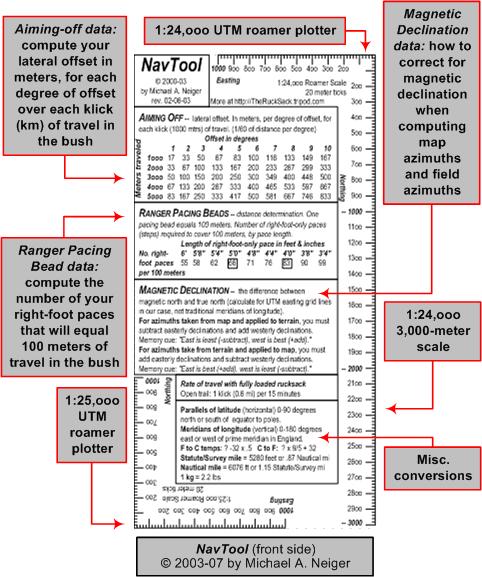
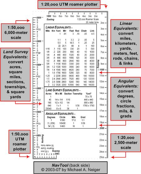
Land nav crib
card
The copyrighted, two-sided, laminated, 3-by-5-inch NavTool crib card depicted below contains a lot of land nav information that is useful on many on remote, long-range land nav ops, especially when doing a lot of technical, off-trail navigation.
If you would like a free NavTool crib card for use on our next trip, expedition, or SAR op, e-mail me in advance and I will bring one along for you.
Commercial UTM and LAT/LON plotters are available from the following vendors:
Ben Meadows Company
1-800-241-6401Brooks-Range Mountaineering Equipment Co.
1-718-585-1717Brunton Company
1-800-443-4871
See "map quad tool"Forestry Suppliers, Inc.
1-800-647-5368Lat.26Inc
1-800-305-0036The Map Store
1-877-921-6277Map Tools
1-650-529-9410Mountains Plus
1-877-411-4327Ranger Joe's
1-800-247-4541Search Gear
1-800-474-2612Waypoint Enterprises
1-888-412-260
I believe that there is
a subtle magnetism in Nature,
which, if we unconsciously yield to it,
will direct us aright.
—Henry David Thoreau (1817-1862),"Walking," Atlantic Monthly, June 1862
Top
of page
Topographic map
preparation
Waterproof all maps
Rain, mud, river water, wet snow, and DEET are hard on maps, so consider waterproofing your maps with a commercial waterproofer (or Thompson's watersealer). To further protect them in the bush, carry them in heavy-duty, gallon-size, zip-lock, plastic bags.
Suppliers of AquaSeal® Map Seal® include Campmor at 1-800-226-7667.
Overlay maps with UTM grid if necessary
If your maps do not have the Universal Traverse Mercator (UTM) grid lines already overlaid on them, consider adding UTM grid lines to them. We rely heavily on the easting and northing UTM grid lines for land navigation in the bush. In addition to occasionally using them to either calculate a UTM coordinate from the map or plot a GPS-derived UTM coordinate on the map, we use them hour after hour, day after day for calculating azimuths, measuring route distances, and pace counting.
Wear topo map on forearm for easy access
If you need your hands free for negotiating thick bush, using ski poles or walking sticks, or climbing, but still want to keep an eye on your map, consider bringing a couple of large-diameter rubber bands as well as a spare one. By folding your zip-lock-bag-protected map to size, wrapping it around your forearm of choice like a splint, and then securing it with two rubber bands, you'll be able to keep one eye on your topo and the other on the azimuth you're cutting while on point.
Top
of page
U.S. Army Ranger
pacing beads
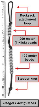
U.S. Army Ranger pacing beads are handy for measuring distances while underway in the bush, particularly when dead reckoning or trying to reconcile the map with the terrain, or vice versa. To learn more about U.S. Army Ranger pacing beads, click here.
If you're carrying ranger pacing beads, inventory the 100-meter beads (the lower set of beads) to make sure there are nine of them. Several commercially-manufactured units come with fragile, plastic beads, which crack and fall off when handled roughly in the bush.
If you would like a free set of ranger pacing beads for use on our next trip, expedition, or SAR op, e-mail me in advance and I will bring along a set for you.
Top
of page
Heavy-duty wrist
compass with brush guard
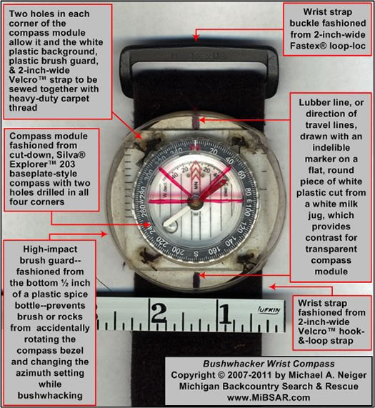
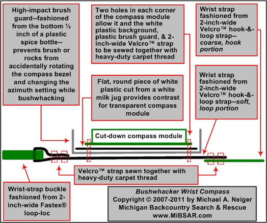
A heavy-duty, hands-free compass with a brush guard is very handy for cutting azimuths, hour after hour, day after day, through steep or tangled terrain. While none are commercially available, it is relatively easy to fabricate one from a conventional, high-quality baseplate compass.
Suppliers of the Silva Explorer 203 Baseplate Compass used to fabricate the Bushwhacker Wrist Compass pictured and illustrated above include The Compass Store. More compass manufacturers and vendors.
Suppliers of the Velcro™ hook-and-loop and Fastex® hardware used to fabricate the Bushwacker Wrist Compass include Outdoor Wilderness Fabrics, Inc. at 1-800-693-7467 and Quest Outfitters at 1-800-359-6931. More fabric and hardware vendors.

Top
of page
Pencil and paper
A short pencil (or waterproof pen) is handy for plotting UTM coordinates on maps as well as annotating them. On complicated routes—especially when dead reckoning—a piece of waterproof paper is handy for recording azimuths, distances, elapsed times, terrain features, and other field data.
On SAR op missions, additional paper is often required for making sketches and recording pertinent data on activities and observations.
Suppliers of Rite-in-the-Rain® all-weather paper and pens include the Ben Meadows Company at 1-800-241-6401 and Forestry Suppliers, Inc. at 1-800-647-5368.
Top
of page
GPS units
No matter what brand or model of GPS unit you're carrying in your ruck, make sure it is properly configured, and don't be surprised if deep gorges, tall cliffs, heavy rain or snow, deep cold, or thick, double canopy limit its usefulness at times.
Getting some units to lock onto the requisite number of satellites has been a challenge in the past, which is why we strive to always know where we are within a few hundred meters by conventional map-and-compass techniques.
In certain locations, it may be necessary to emerge from the bush at a rocky peak, river bank, lakeshore, or open marsh before a GPS will work properly.
To increase a unit's usefulness on remote, long-range trips, expeditions, and SAR ops—particularly in deep, arctic cold—consider equipping it with lithium batteries as they tend to last longer and are largely unaffected by deep cold, unlike alkaline batteries.
I shall be telling this with a sigh—
somewhere ages and ages hence;
two roads diverged in a wood,
and I—I took the one less traveled by,
and that has made all the difference.
—Robert Frost (1874-1963), The Road Not Taken, 1916, stanza 4
Return to top of page :: Return to home page
In God's wilderness
lies the hope of the world,
the great, fresh, unblighted,
unredeemed wilderness.
—
John Muir, 1838-1914
Alaska Wilderness, 1890
If
you've been able to read this Web page...
thank a Teacher;
If you've been able to read this Web page in English...
thank a Veteran.
—Author
unknown
•
Copyright notice •
Content Copyright © 1984 --
2010-11-04
by Michael A. Neiger
• All rights reserved •
No part of this Web page or this Web site protected by copyright law may be reproduced, transmitted, or used in any form--including graphic, electronic, Web, mechanical or other form--or by any means--including photocopying, recording, taping, Internet distribution, information storage retrieval system, or by other means--for any purpose, except by a reviewer, who may quote brief passages, without the prior, express, written permission of the author.
Comments?
Suggestions?
Dead links? Inaccurate info?
Contact the WebMaster, Michael A. Neiger, at mneiger@hotmail.com
Web site URL: www.MibSAR.com
Return to top of page :: Return to home page
You're here: MiBSAR's home page :: Essential SAR bush gear index page :: Land nav bush gear page