
You're here: MiBSAR's home page :: SAR operations log page :: SAR op photo-journal page
Michigan
Backcountry Search and Rescue (MiBSAR)
SAR Op No. 14 photo-journal:
Joe Clewley missing-person investigation
By
Michael Neiger
Marquette, Michigan
© Copyright 2008
Duration & date: Agency assisted:
_____________________
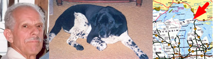
Sault Ste. Marie, MichiganTownship & County: Nearest place-name: General location: Tahquamenon Falls State Park in the eastern Upper Peninsula Trail: Victim: Joseph Robert Clewley
White male; age 73; 5'-10"; 150 lbsCase summary: Joe Clewley and his dog Chip went missing on July 13, 2008. His van was found parked at the North Country Trail (NCT) trailhead along the Tahqua Trail in the eastern reaches of Tahquamenon Falls State Park. Joe owned a log cabin in the area and enjoyed hiking off-trail in the park. SAR op mission: MiBSAR team members: Partner SAR teams & assets: SAR op results: Joe Clewley was not located Additional resources: • Learn more about this investigation
• View official, Sheriff's Office-provided Web site for victim
• View MiBSAR-provided Web site and Internet blog for victim

Wednesday, October 22
Day 1 was spent working the marsh-like fingers projecting westward from the Lynch Creek Grade Pond.


A panoramic view of the Lynch Creek Grade Pond, as viewed from the peninsula jutting out from its western limit. Click on photo for high-resolution imagery. (Photo by Michael Neiger)
It was very cold all day, so much so that many ponds remained iced-over throughout the day.

The surface of a small pond is still frozen at 5:30 p.m. Click on photo for high-resolution imagery. (Photo by Michael Neiger)
Sunset over the Lynch Creek Grade Pond. Click on photo for high-resolution imagery. (Photo by Michael Neiger)


Thursday, October 23
Thanks to a thicker sleeping bag, an additional layer of insulating clothing, and felt-lined winter boots, I was able to stay warm in Joe's Country, unlike my last trip, where I was very cold.


Sunrise over the Lynch Creek Grade Pond. Click on photo for high-resolution imagery. (Photo by Michael Neiger)
Tarp bivouac site on the Lynch Creek Grade Pond. Click on photo for high-resolution imagery. (Photo by Michael Neiger)


The view from under the tarp. Click on photo for high-resolution imagery. (Photo by Michael Neiger)
After a hot breakfast of granola, blueberries, and hot chocolate, I shouldered my ruck and set off to recon the northern reaches of the Lynch Creek Headwaters Swamp for a route that Joe may have used.
An old, dried-up, frost-laden beaver flooding along the western limit of the Lynch Creek Headwaters Swamp. Click on photo for high-resolution imagery. (Photo by Michael Neiger)
A birch outgrows its stump-turned-pot container. Click on photo for high-resolution imagery. (Photo by Michael Neiger)


A panoramic view of the Lynch Creek Grade Pond, as viewed from the Grade at its northeastern corner. Click on photo for high-resolution imagery. (Photo by Michael Neiger)
After some careful sign-cutting, I picked up the remains of a trail--several intermittent old ax blazes that had been painted red many, many years ago--that marked a totally-overgrown route leading eastward across the swamp.
After two to three hundred meters of nasty bushwhacking, I picked up the western end of a relatively-brushed-out single track trail that lead eastward to the bank of Cheney Creek.
An old ax blaze painted red marks a long-abandoned route across the northern limit of the Lynch Creek Headwaters Swamp. Click on photo for high-resolution imagery. (Photo by Michael Neiger)
Once at the west bank of Cheney Creek, I headed south to look for another route leading back into the heart of the massive Lynch Creek Headwaters Swamp.
After consulting the detailed satellite images that my partner--Chris Ozminski (NightBlazer) of Frankenmuth, Michigan--had painstakingly assembled a few weeks earlier, I was able to locate another route that a bushman like Joe would certainly have known about, and perhaps used from time to time. This trail traced the length of a very low, pine-studded ridge that ended near the middle of the open marsh in the swamp.
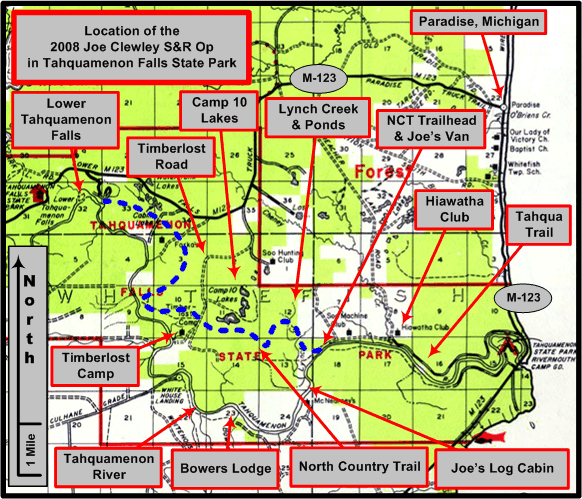
An overview of the Joe Clewley search area in the eastern Upper Peninsula of Michigan, southwest of Paradise, in the Tahquamenon Falls State Park. (Graphic by Michael Neiger)
Two hundred meters of hummock hopping put me in the opposite treeline, from which I bushwhacked southwest to the powerline. From here, I picked up an old logging-era railroad grade that Chris has spotted on the satellite photos and reconned earlier. Just as he said, its entire length served as a game trail, much of which was wide open and easy walking. While hidden from the casual visitor, Joe would certainly have known of this route too.
After hiking this old grade to its terminus near the Lynch Creek Headwaters Swamp, I rigged my tarp for another cold bivouac in Joe's Country.


Friday, October 24
When I awoke in the morning, my tarp was heavily laden with ice and frost.
The view from my tarp bivouac along the southern edge of the Lynch Creek Headwaters Pond. Click on photo for high-resolution imagery. (Photo by Michael Neiger)
Winter seems to have arrived in Joe's Country. This snowball was fashioned from some of the frost and ice that was scraped from my tarp in the morning. Click on photo for high-resolution imagery. (Photo by Michael Neiger)
Breakfast down and my ruck packed, I struck out northward across the Lynch Creek Headwaters Swamp. Along the way, I worked numerous game trails. Deep in a tangled section of cedar swamp, I happened across a scatter of large bones that appeared to have been from a moose.


A scatter of moose bones--including the business-end of a hoof (rightmost photo)--found deep in the Lynch Creek Headwaters Swamp. Scatter of bones assembled for photographic purposes; rule is 24 inches in length. Click on photo for high-resolution imagery. (Photo by Michael Neiger)
After I emerged from the swamp along its western limit, I headed southward, tracing a route along it western edge for any sign of Joe. Finding none, I eventually headed home to prepare for the next SAR Op, which was scheduled for the first weekend in November.


Return to top of page :: Return to home page
In God's wilderness
lies the hope of the world,
the great, fresh, unblighted,
unredeemed wilderness.
—
John Muir, 1838-1914
Alaska Wilderness, 1890
If
you've been able to read this Web page...
thank a Teacher;
If you've been able to read this Web page in English...
thank a Veteran.
—Author
unknown
•
Copyright notice •
Content Copyright © 1984 --
2009-09-16
by Michael A. Neiger
• All rights reserved •
No part of this Web page or this Web site protected by copyright law may be reproduced, transmitted, or used in any form--including graphic, electronic, Web, mechanical or other form--or by any means--including photocopying, recording, taping, Internet distribution, information storage retrieval system, or by other means--for any purpose, except by a reviewer, who may quote brief passages, without the prior, express, written permission of the author.
Comments?
Suggestions?
Dead links? Inaccurate info?
Contact the WebMaster, Michael A. Neiger, at mneiger@hotmail.com
Web site URL: www.MibSAR.com
Return to top of page :: Return to home page
You're here: MiBSAR's home page :: SAR operations log page :: SAR op photo-journal page