
You're here: MiBSAR's home page :: SAR operations log page :: SAR op photo-journal page
Michigan
Backcountry Search and Rescue (MiBSAR)
SAR Op No. 10 photo-journal:
Joe Clewley missing-person investigation
By
Michael Neiger
Marquette, Michigan
© Copyright 2008
Duration & date: Agency assisted:
_____________________
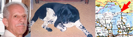
Sault Ste. Marie, MichiganTownship & County: Nearest place-name: General location: Tahquamenon Falls State Park in the eastern Upper Peninsula Trail: Victim: Joseph Robert Clewley
White male; age 73; 5'-10"; 150 lbsCase summary: Joe Clewley and his dog Chip went missing on July 13, 2008. His van was found parked at the North Country Trail (NCT) trailhead along the Tahqua Trail in the eastern reaches of Tahquamenon Falls State Park. Joe owned a log cabin in the area and enjoyed hiking off-trail in the park. SAR op mission: MiBSAR team members: Partner SAR teams & assets: SAR op results: Joe Clewley was not located Additional resources: • Learn more about this investigation
• View official, Sheriff's Office-provided Web site for victim
• View MiBSAR-provided Web site and Internet blog for victim

Wednesday, September 24
I arrived in Joe's Country just as the sun was setting. After capturing a few photos and parking my vehicle near the trailhead, I shouldered my ruck and spent the next couple hours combing the North Country Trail (NCT) for any new sign of Joe Clewley with my headlamp.


Sunset over Joe's Country from M-123 and the north bank of the Tahquamenon River, respectively. Click on photo for high-resolution imagery. (Photo by Michael Neiger)
When I reached the switchbacks, I left the NCT and headed for the southeastern corner of the Camp 10 Chain of Lakes, where I established a hasty bivouac in a forest dripping with water from a day of rain.
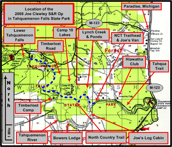
An overview of the Joe Clewley search area in the eastern Upper Peninsula of Michigan, southwest of Paradise, in the Tahquamenon Falls State Park. (Graphic by Michael Neiger)


Thursday, September 25
After a hearty breakfast and cup of hot chocolate, I stuffed my bivouac gear in my ruck and worked my way up to the east shore of Lake 714 where I cached my bivouac gear for a day of recon. Along the way, I spotted a bald eagle flying low along the shoreline of one of the lakes in the area.


The Camp 10 Chain of Lakes. Note white swans in the second and third photos. Click on photo for high-resolution imagery. (Photo by Michael Neiger)
Before the day was over, I'd worked the all of the ridgelines east and north of the Camp 10 Chain of Lakes that I have not reconned on several earlier SAR Ops.
Hair from a white-tailed deer in the Camp 10 Chain of Lakes area. Click on photo for high-resolution imagery. (Photo by Michael Neiger)
With the sun just about ready to set, I returned to my cache near Lake 714 and established my night bivouac. I enjoyed dinner and a cup of Chai as the sun set over Joe's Country. As I sat quietly along the shore, I watched a flying squirrel dart from tree to tree as a kingfisher flew low over the lake.


Sunset over Lake 714 in Camp 10 Chain of Lakes. Click on photo for high-resolution imagery. (Photo by Michael Neiger)
During the evening, I listened to a chorus of howling coyotes from both 100 magnetic degrees and 190 magnetic degrees on the compass rose. At one point, I listened to a single coyote down in the swamp bark for what seemed like ten minutes or more at 100 magnetic degrees.


Friday, September 26
Well rested, I arose to the sun lighting up Lake 714. After breakfast, I stuffed all my gear in my ruck and headed east.

Sunrise over Lake 714 in Camp 10 Chain of Lakes. Click on photo for high-resolution imagery. (Photo by Michael Neiger)
I worked several ridgelines and a hemlock-studded rise in the swamp before I emerged along the western limit of the expansive marsh along the upper west branch of Lynch Creek, north of the NCT.

Working the ridgelines east of the Camp 10 Chain of Lakes. Click on photo for high-resolution imagery. (Photo by Michael Neiger)


The expansive marsh on the upper west branch of Lynch Creek, upstream of the North Country Trail, as viewed from its western edge. Click on photo for high-resolution imagery. (Photo by Michael Neiger)
After skirting the edge of the marsh, I hiked up the Lynch Creek Grade, stopping at one point to inspect several giant ferns, one of which measured 55 inches in height.


The Lynch Creek Grade and foot trail. Click on photo for high-resolution imagery. (Photo by Michael Neiger)
Once at the ruins of the Cabins, I bushwhacked west to locate the northernmost limit of the marsh along the upper west branch of Lynch Creek. Once I emerged at the marsh, I made two passes along its eastern limit, one along the treeline and one a few meters back from the tree line. Along the way, I noted the concealed entrance to a bear den. I decided to wait to explore it until my partner Chris Ozminski arrived in the morning.
Tired from a long, hot day of recon, I established my night bivouac in a small clearing that was screened from view along the eastern limit of the swamp. As the sun set, I quietly awaited the arrival of moose, deer, or bear; my wait went unrewarded. However, before I feel asleep in my bivouac sack, I heard two hoot owls, and watched as fire flies and shooting stars lit up the sky.


Friday night's bivouac and sunset along the eastern flank of the the expansive marsh on the upper west branch of Lynch Creek, upstream of the North Country Trail. Click on photo for high-resolution imagery. (Photo by Michael Neiger)


Saturday, September 27
Just as I arose from a restful night, Chris Ozminski appeared from the marsh. We discussed recent developments in the investigation as I enjoyed a breakfast of granola, blueberries, and hot chocolate.
After we cached our bivouac gear, we set about making a couple more passes along the eastern limit of the marsh. Along the way, I showed Chris the bear den I'd found the day prior. He volunteered to recon it for any physical evidence--bowie close at hand--while I monitored the situation near the entrance.


Chris Ozminski reconning the depths of one of two bear dens he and MIchael Neiger found along the eastern limit of the marsh on the upper west branch of Lynch Creek, just upstream of the North Country Trail (NCT). Click on photo for high-resolution imagery. (Photo by Michael Neiger)
After disappearing for what seemed like too long, he emerged empty handed.
View a 43-second video of Chris Ozminski reconning the depths of one of two bear dens he and MIchael Neiger found along the eastern limit of the marsh on the upper west branch of Lynch Creek, just upstream of the North Country Trail (NCT). Click on image to view video. (Video by Chris Ozminski)
Once we'd completed our work along the east side of the marsh, we stuffed our bivouac gear in our rucks and headed north along the remnants of the Lynch Creek Grade. On our way north we checked out several areas east and west of the grade. We eventually spent a few hours rechecking a previously-visited area for physical evidence.
Our day's work complete in the late afternoon rain, we shouldered our rucks and headed for the Lynch Creek Grade Pond where we established our night bivouac.
With dinner down, we mapped out our search plan for the next day and retired. Shortly after we'd climbed in our bivies, we heard a beaver working in the pond.


Sunday, September 28
After breakfast, we cached our bivouac gear and proceeded to recon the bush southwest of the pond.


Chris Ozminski fixes breakfast at his bivouac on the Lynch Creek Grade Headwaters Pond. Click on photo for high-resolution imagery. (Photo by Michael Neiger)

Chris Ozminski searches a finger-marsh along the western limit of the Lynch Creek Grade Headwaters Pond. Click on photo for high-resolution imagery. (Photo by Michael Neiger)
Finding nothing of note in the bush southwest of the pond, we stuffed our bivouac gear in our rucks and worked the remnants of the grade northeastward until it reached the trail running along the west bank of Cheney Creek.

New growth accommodates old growth near a finger-marsh along the western limit of the Lynch Creek Grade Headwaters Pond. Click on photo for high-resolution imagery. (Photo by Michael Neiger)


Two parting shots of the Lynch Creek Grade Headwaters Pond. Click on photo for high-resolution imagery. (Photo by Michael Neiger)

Chris Ozminski inspects a massive, decaying old-growth stump just north of the Lynch Creek Grade Pond. Click on photo for high-resolution imagery. (Photo by Michael Neiger)
Once on the trail near along Cheney Creek, we headed south. Along the way, we came upon an old rusting Plymouth.


Chris Ozminski inspects an old rusting Plymouth along the Cheney Creek west bank trail. Click on photo for high-resolution imagery. (Photo by Michael Neiger)
When we came to the foot trail that cuts through the heart of the Lynch Creek Headwaters Swamp, we worked it southwest until we'd crossed the swamp proper, cut the power line, and arrived the old Soo Machine Club on the Tahqua Trail.


A low ridge that cuts the Lynch Creek Headwaters Swamp. Click on photo for high-resolution imagery. (Photo by Michael Neiger)
As we walked down the Tahqua Trail towards our vehicles, we discussed what we had accomplished during the SAR Op and what we needed to get done when we returned next week.


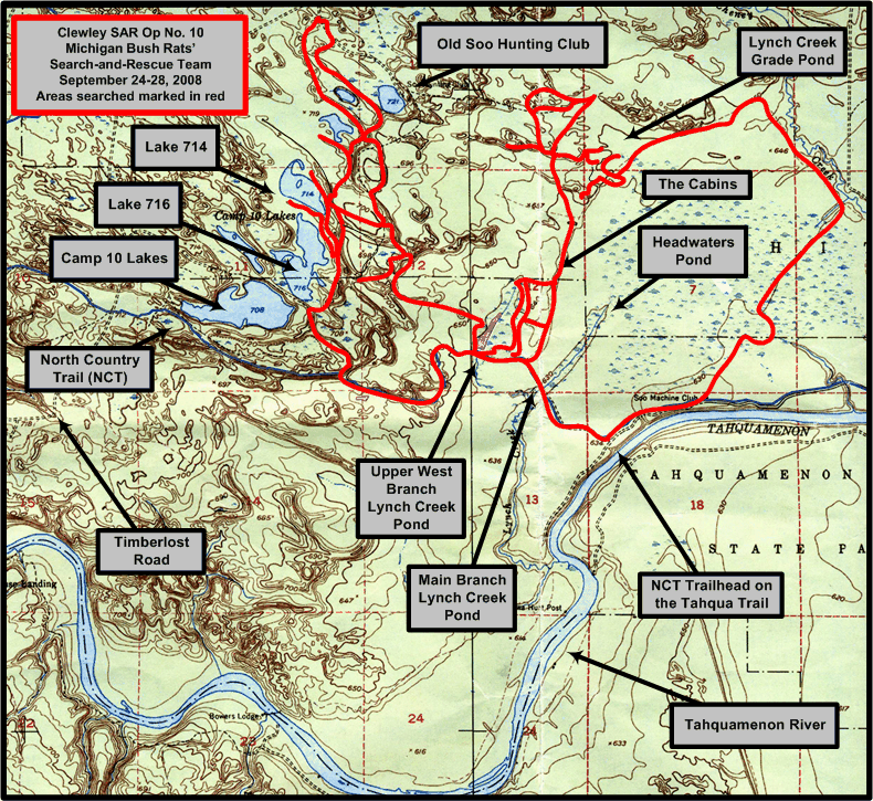
1:24,000 USGS quad showing areas searched (in red) by the Michigan Backcountry Search and Rescue Team during Clewley SAR Op No. 10, September 24-28, 2008. (Base quad with North Country Trail [NCT] plot and UTM grid overlay courtesy of Chuck McCready's No Boundaries Maps and Graphics, Inc., of Sault Ste. Marie, Michigan, an official sponsor of the Michigan Backcountry SAR Team. Annotations by Michael Neiger)
Return to top of page :: Return to home page
In God's wilderness
lies the hope of the world,
the great, fresh, unblighted,
unredeemed wilderness.
—
John Muir, 1838-1914
Alaska Wilderness, 1890
If
you've been able to read this Web page...
thank a Teacher;
If you've been able to read this Web page in English...
thank a Veteran.
—Author
unknown
•
Copyright notice •
Content Copyright © 1984 --
2009-09-16
by Michael A. Neiger
• All rights reserved •
No part of this Web page or this Web site protected by copyright law may be reproduced, transmitted, or used in any form--including graphic, electronic, Web, mechanical or other form--or by any means--including photocopying, recording, taping, Internet distribution, information storage retrieval system, or by other means--for any purpose, except by a reviewer, who may quote brief passages, without the prior, express, written permission of the author.
Comments?
Suggestions?
Dead links? Inaccurate info?
Contact the WebMaster, Michael A. Neiger, at mneiger@hotmail.com
Web site URL: www.MibSAR.com
Return to top of page :: Return to home page
You're here: MiBSAR's home page :: SAR operations log page :: SAR op photo-journal page