
You're here: MiBSAR's home page :: SAR operations log page :: SAR op photo-journal page
Michigan
Backcountry Search and Rescue (MiBSAR)
SAR Op No. 8 photo-journal:
Joe Clewley missing-person investigation
By
Chris Ozminski
Frankenmuth, Michigan
© Copyright 2008
Duration & date: Agency assisted:
_____________________
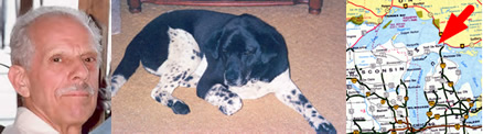
Sault Ste. Marie, MichiganTownship & County: Nearest place-name: General location: Tahquamenon Falls State Park in the eastern Upper Peninsula Trail: Victim: Joseph Robert Clewley
White male; age 73; 5'-10"; 150 lbsCase summary: Joe Clewley and his dog Chip went missing on July 13, 2008. His van was found parked at the North Country Trail (NCT) trailhead along the Tahqua Trail in the eastern reaches of Tahquamenon Falls State Park. Joe owned a log cabin in the area and enjoyed hiking off-trail in the park. SAR op mission: MiBSAR team members: Partner SAR teams & assets: SAR op results: Joe Clewley was not located Additional resources: • Learn more about this investigation
• View official, Sheriff's Office-provided Web site for victim
• View MiBSAR-provided Web site and Internet blog for victim

Friday, September
12
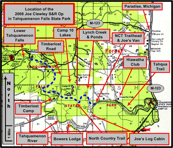
An overview of the Joe Clewley search area in the eastern Upper Peninsula of Michigan, southwest of Paradise, in the Tahquamenon Falls State Park. (Graphic by Michael Neiger)
Segment A
Objective: Reconnoiter an unusual straight line (as seen in aerial photos) through vegetation in the Lynch Creek Headwaters wetland vicinity. This "line" looked like a possible route connecting the power line clearing to the end of Lynch Creek Headwaters Pond Foot Trail.
1:24,000 USGS quad showing areas searched (in red) by the Michigan Backcountry Search and Rescue Team during Clewley SAR Op No. 8, September 12-13, 2008. (Base quad with North Country Trail [NCT] plot and UTM grid overlay courtesy of Chuck McCready's No Boundaries Maps and Graphics, Inc., of Sault Ste. Marie, Michigan, an official sponsor of the Michigan Backcountry SAR Team. Annotations by Chris Ozminski)
9/12/08, 7:39pm, 646201E 5158248N Roadside on the Tahqua Trail
Clear Sky, Cool; Mosquitoes sluggish but active; Sun down below skyline.Begin Search Operation.
8:02pm 645267E, 5158248N Northwest corner of intersection between powerline and narrow wetland
Began cut for sign on a West heading parallel to the power line 15 meters north into the woods. After approximately 50 meters a tread (compacted ground of a worn path) was located. It's 331 degree compass heading and straight-line nature indicated it probably was the objective. Although at this point the tread was somewhat intermittent and looked like many other game trails in this area.

Lynch Creek Headwaters Grade looking southeast and northwest, respectively. Click on photo for high-resolution imagery. (Photo by Chris Ozminski)
8:35pm 644913E 5158737N Bivouac site beside roadbed
After 150 meters it became apparent by the growth pattern of the vegetation that a road (probably logging era railroad) had existed here in the distant past. This was also evidenced by a very level, straight, flat-topped , and often raised (with adjacent borrow pits) pathway . Bivouac was established beside the road at this time as it had become too dark for effective searching.
Bivouac site along the Lynch Creek Headwaters Grade. Click on photo for high-resolution imagery. (Photo by Chris Ozminski)


Saturday, September
13
9/13/08 8:03am Lynch Creek Headwaters Grade
Overcast Sky, Cooler; No mosquito activity; Wet fog - mist, enough daylight to resume search.
Leaving the bivouac gear behind, backtracked to the power line for a more thorough search.
9:31am Lynch Creek Headwaters Pond Foot Trail at the beaver dam
Retrieved bivouac gear and completed the reconnoiter of the grade to where it met the Lynch Creek Headwaters Pond Foot Trail approximately 100 meters north of the beaver dam.
Conclusion: The road was found to be easily passable and makes an interesting connection between known routes. This area was also one of the most prolific with game trails yet seen on prior searches. More search activity in the vicinity may be warranted.
Segment B
Objective: Make a perimeter sweep of the "game trail crossing area" 100 - 200 meters directly east of The Cabins and look for access routes. This area was located during SAR Op No 4 and noted for possible further search activity. It is an area where somewhat sparser brush and abundant game trails make it much more navigable than the surrounding tag alder swamps.
9/13/08 10:02am 6465547E 5158911N Southwest corner of the game trail crossing area
Partly Sunny Sky, Warming; Mosquitoes active; Fog mostly dissipated.
After crossing the Lynch Creek Headwaters Pond Dam a counterclockwise sweep of the east and north sides of the area met very thick brush with no likely routes of travel found.
11:03am The Cabins Clear Sky, Warm - mosquitoes and flies active.
100 meters east of The Cabins a grassy clearing with little brush was located adjacent to the west side of the game trail crossing area. This clearing is long and narrow, paralleling The Cabins clearing and about the same length. It shows on aerial photos taken in April 1998. It is easily accessible through the relatively open woods between it and The Cabins.
Conclusion: The only reasonable access found to this area is from The Cabins and to a much lesser degree (due to somewhat thick brush) from the Lynch Creek Headwaters Pond Dam.
Segment C
Objective: Reconnoiter a possible route from The Cabins to the Lynch Creek West Branch Headwaters marsh. This possible route was located during aerial photo analysis. After also making a sweep through the upper end of the marsh, proceed west to an area with mature woods as seen in aerial photos, looking for areas of interest and access routes in that relatively little searched area.
9/13/08 12:30pm 644000E 5158986N Upper End of Lynch Creek West Branch Headwaters Marsh
The route from The Cabins was fairly open the only difficulty was staying in the open areas (i.e. not getting drawn into dead ends in a tag alder swamp) and a short 15 meter stretch through thick brush. There are nice distant views from the top end of the west branch marsh. It appeared that there may be access routes through the opens woods south of The Cabins. That part of the wetland was actually dry and firm with little vegetation obstructing travel for quite a distance.
Headwaters marsh along Upper West Branch of Lynch Creek. Click on photo for high-resolution imagery. (Photo by Chris Ozminski)
12:58pm 643784E 5159829N Mature woods west of the Lynch Creek West Branch Headwaters Marsh
Overcast sky, Warm; Mosquitos and flies active.
After 200 meters of tag alder and immature cedar swamp open hardwoods were found mixed with areas of thicker undergrowth. Some very large Yellow Birch, Cottonwood, and Maples were present. There were also several fallen trees with huge root balls standing on edge the largest at least 20 feet in diameter and containing multiple trees and saplings. Lunch time.
Huge yellow birch. Click on photo for high-resolution imagery. (Photo by Chris Ozminski)
Massive root ball from toppled tree. Click on photo for high-resolution imagery. (Photo by Chris Ozminski)
1:57pm 643368E 5159829N Western Limit of Segment C
After lunch no reasonable access from the south or west was discerned. More of the same type of hardwoods was encountered. Traveled northeast crossing through a gap in the ridge to begin segment D.
Conclusion: The west branch marsh is a high interest area. Looking for more likely access routes could be useful as well as further exploration of the wetland. The Hardwoods west of the wetland are difficult to access and seem unlikely for further searching unless new information points in that direction.
Segment D
Objective: Reconnoiter another little searched area including a wetland and/or clearing seen on aerial photos and an isolated ridgeline indicated on topographic maps.
9/13/08 3:09pm 643636E 515829N Isolated Ridge
Increasing Cloud Cover, Slightly cooler; Mosquitoes active, fly activity minimal; Rain threatening.
After passing through the west side of the mostly dried up wetland no reasonable routes of travel were encountered through 400 meters of tag alder and immature cedar swamps before reaching the isolated ridge.
4:00pm 643375E 5159900N West end of Isolated Ridge
The ridge had several clear areas along it's top. It was not high enough to provide any distant views. Also noted was the recumbent half shell of a large old growth white pine that looked like a dugout canoe. It had been scorched by fire many many years ago which probably helped preserve it. The isolated ridge extended northwest just below the contour line elevation on the topographic map and ended about 30 meters from the much larger ridge located mostly to the north.
Old-growth-turned-dugout tree. Click on photo for high-resolution imagery. (Photo by Chris Ozminski)
Conclusion: The wetland is fairly inaccessible. The ridge running to it from the west was explored during SAR Op No 4 and it too was somewhat difficult going. The isolated ridge was an interesting place and easily accessible from the larger ridge to the north.
Segment E
Objective: Make a long sweep from west to east between a large long ridge on the south and an established foot trail along a old logging railroad grade both of which have been reconnoitered on earlier SAR Ops.
9/13/08 4:21pm 643597E 5160128 Start of long sweep
After crossing through a gap in the long ridge, somewhat open woods were encountered as well as several small ridges and hills apparently to low to register on the topographic map.
4:59pm 644140E 5160049 Split Hill
After approximately 250 meters the small ridges turned into flat semi-open woods until encountering a hill shown with a gap in it on the topographic map. An old roadbed had been cut through that hill creating the gap on the map. That road looked to be a very well used foot (and possibly ATV) trail. Following it north it joined the east - west railroad grade at 644051E 5160072N. It seemed likely that to the south it would join with the Lynch Creek Grade Foot Trail.
6:20pm 644526E 5159922 Near logging camp foundation on Lynch Creek Grade and Foot Trail
Dark Overcast Sky, warm; Mosquito's active; Light steady rain.
The woods were more mature and open east of the split hill but several areas with a lot of downed trees made navigation more difficult. The western reaches of the Lynch Creek Grade Flooding were mostly dried up and an interesting area for wildlife viewing. South from there was also a lot of fallen trees and some undergrowth obstructing travel. The road from the split hill was not encountered during that stretch as expected.
Search Plan completed ahead of schedule it was decided to end the Op 8 early as the rain would likely last quite some time being it was the remnants of Hurricane Ike.
Conclusion: No new areas of interest were found. If the road through split hill does connect with the Lynch Creek Grade it would provide good access to those northern areas of interest.
9/1308 6:40pm 644452E 5159474N Possible fork in Lynch Creek Grade that is the road running up through the split ridge.
While traveling back to the vehicle on Lynch Creek Grade and Foot Trail a probable roadbed heading north was noticed behind a small cluster of small spruce or cedar. After following this route for 100 meters it was found to be easily traveled though not easily discerned. It seemed likely that this route was already known to searchers if indeed it does go through to the east - west grade to the north. Later discussions with Michael Neiger revealed that this route was not known and it should be investigated on future Operations.
Note: All grid coordinates from UTM Zone 16 NAD 27.


Return to top of page :: Return to home page
In God's wilderness
lies the hope of the world,
the great, fresh, unblighted,
unredeemed wilderness.
—
John Muir, 1838-1914
Alaska Wilderness, 1890
If
you've been able to read this Web page...
thank a Teacher;
If you've been able to read this Web page in English...
thank a Veteran.
—Author
unknown
•
Copyright notice •
Content Copyright © 1984 --
2009-09-16
by Michael A. Neiger
• All rights reserved •
No part of this Web page or this Web site protected by copyright law may be reproduced, transmitted, or used in any form--including graphic, electronic, Web, mechanical or other form--or by any means--including photocopying, recording, taping, Internet distribution, information storage retrieval system, or by other means--for any purpose, except by a reviewer, who may quote brief passages, without the prior, express, written permission of the author.
Comments?
Suggestions?
Dead links? Inaccurate info?
Contact the WebMaster, Michael A. Neiger, at mneiger@hotmail.com
Web site URL: www.MibSAR.com
Return to top of page :: Return to home page
You're here: MiBSAR's home page :: SAR operations log page :: SAR op photo-journal page