
You're here: MiBSAR's home page :: SAR operations log page :: SAR op photo-journal page
Michigan
Backcountry Search and Rescue (MiBSAR)
SAR Op No. 7 photo-journal:
Joe Clewley missing-person investigation
By
Michael Neiger
Marquette, Michigan
© Copyright 2008
Duration & date: Agency assisted:
_____________________
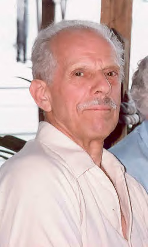
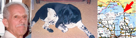
Sault Ste. Marie, MichiganTownship & County: Nearest place-name: General location: Tahquamenon Falls State Park in the eastern Upper Peninsula Trail: Victim: Joseph Robert Clewley
White male; age 73; 5'-10"; 150 lbsCase summary: Joe Clewley and his dog Chip went missing on July 13, 2008. His van was found parked at the North Country Trail (NCT) trailhead along the Tahqua Trail in the eastern reaches of Tahquamenon Falls State Park. Joe owned a log cabin in the area and enjoyed hiking off-trail in the park. SAR op mission: MiBSAR team members: Partner SAR teams & assets: SAR op results: Joe Clewley was not located Additional resources: • Learn more about this investigation
• View official, Sheriff's Office-provided Web site for victim
• View MiBSAR-provided Web site and Internet blog for victim
Sunday, September
7
I arose just after sunset, having bivouacked in a stand of jack pine at the southern limit of the Lynch Creek Headwaters Swamp.
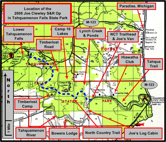
An overview of the Joe Clewley search area in the eastern Upper Peninsula of Michigan, southwest of Paradise, in the Tahquamenon Falls State Park. (Graphic by Michael Neiger)
I had hiked into the spot by headlamp late on Saturday night, after finishing a 3-day Wilderness First-Aid and CPR course in Marquette.
A stand of jack pine along the southern limit of the Lynch Creek Headwaters Swamp. Click on photo for high-resolution imagery. (Photo by Michael Neiger)
After a hearty breakfast and a mug of hot chocolate, I began working the first of several areas sandwiched between the southern limit of the Lynch Creek Headwaters Swamp and the east-west-running powerline. Along the way, I saw a lot of bear sign.
Three examples of black bear aerial spoor on a power pole situated along the southern limit of the Lynch Creek Headwaters Swamp: hair, bear grease, and claw marks. Click on photo for high-resolution imagery. (Photo by Michael Neiger)
By late afternoon, I had traveled far enough east to bump into the lands of the Hiawatha Hunt Club, a nearly century-old collection of lodges and tracts of land situated along both sides of Cheney Creek.


Large tracts of land bordering the Lynch Creek Headwaters Swamp to the southeast, east, and northeast are owned by the Hiawatha Hunt Club, which was founded in 1926. Click on photo for high-resolution imagery. (Photo by Michael Neiger)
By early evening, having finished searching most of the areas I had planned near the southern limit of the swamp, I headed westward to the point where the North Country Trail (NCT) cuts the upper west branch of Lynch Creek.
The main branch of Lynch Creek, looking upstream from the point where the North Country Trail (NCT) cuts it. Click on photo for high-resolution imagery. (Photo by Michael Neiger)
Once across the upper west branch, I headed downstream to recon it western bank. With darkness setting in, I established my night bivouac under some old growth near the confluence of the upper west branch and the main branch of Lynch Creek.


Monday, September
8
It rained from time to time during the night, and when I arose in the morning, the bush was dripping wet. After breakfast, I continued working my way down the western side of Lynch Creek.


Working downstream along the west bank of the upper west branch of Lynch Creek, just south of the North Country Trail (NCT). Click on photo for high-resolution imagery. (Photo by Michael Neiger)
Eventually I arrived at a small wooden footbridge spanning the creek. It was situated where an old logging bridge had been located.


The footbridge over the main branch of Lynch Creek along the old logging road turned foot-trail opposite the Monte Cabin. Click on photo for high-resolution imagery. (Photo by Michael Neiger)
Once across the creek, I followed the foottrail easterly until I arrived at the Tahqua Trail, opposite the trail to the Monte Cabin.


The old logging road turned foot-trail opposite the Monte Cabin, near the western limits of the Tahqua Trail. Click on photo for high-resolution imagery. (Photo by Michael Neiger)
From the Tahqua Trail, I returned back to Lynch Creek, reconning its eastern bank, upstream to where its cut by the North Country Trail (NCT).
Along the way, I encountered numerous stands of old growth eastern white pines and eastern hemlocks.


Fungus is a common site along Lynch Creek riverbanks, which are studded with huge specimens old growth eastern white pine and eastern hemlock. Click on photo for high-resolution imagery. (Photo by Michael Neiger)
Having been ill with a nearly-debilitating gut ailment since I arrived--lab tests would later identify one possible culprit: blastocystis hominis--I decided to give up the search for Joe until I felt better.
Good thing I headed home when I did as I did not have many minimally-functional hours left. As I write this journal nearly a week later, I'm finally feeling stronger, and I'm contemplating a return to Joe's Country in the next days.
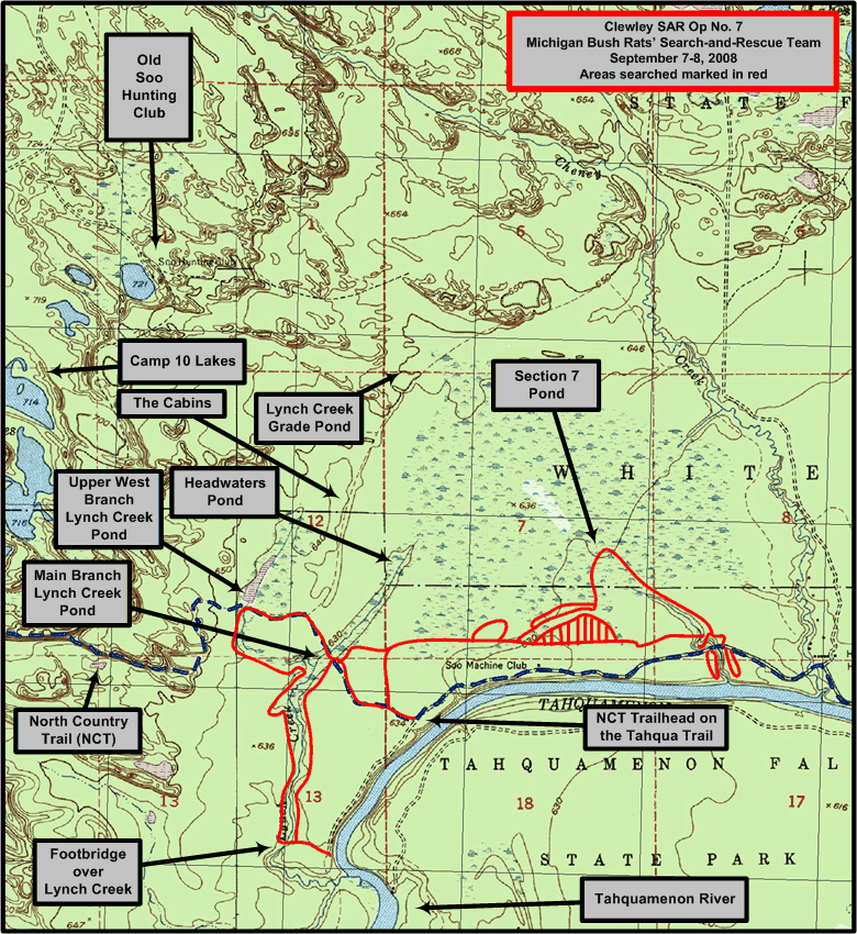
1:24,000 USGS quad showing areas searched (in red) by the Michigan Backcountry Search and Rescue Team during Clewley SAR Op No. 7, September 7-8, 2008. (Base quad with North Country Trail [NCT] plot and UTM grid overlay courtesy of Chuck McCready's No Boundaries Maps and Graphics, Inc., of Sault Ste. Marie, Michigan, an official sponsor of the Michigan Backcountry SAR Team. Annotations by Michael Neiger)


Return to top of page :: Return to home page
In God's wilderness
lies the hope of the world,
the great, fresh, unblighted,
unredeemed wilderness.
—
John Muir, 1838-1914
Alaska Wilderness, 1890
If
you've been able to read this Web page...
thank a Teacher;
If you've been able to read this Web page in English...
thank a Veteran.
—Author
unknown
•
Copyright notice •
Content Copyright © 1984 --
2009-09-16
by Michael A. Neiger
• All rights reserved •
No part of this Web page or this Web site protected by copyright law may be reproduced, transmitted, or used in any form--including graphic, electronic, Web, mechanical or other form--or by any means--including photocopying, recording, taping, Internet distribution, information storage retrieval system, or by other means--for any purpose, except by a reviewer, who may quote brief passages, without the prior, express, written permission of the author.
Comments?
Suggestions?
Dead links? Inaccurate info?
Contact the WebMaster, Michael A. Neiger, at mneiger@hotmail.com
Web site URL: www.MibSAR.com
Return to top of page :: Return to home page
You're here: MiBSAR's home page :: SAR operations log page :: SAR op photo-journal page