
You're here: MiBSAR's home page :: SAR operations log page :: SAR op photo-journal page
Michigan
Backcountry Search and Rescue (MiBSAR)
SAR Op No. 6 photo-journal:
Joe Clewley missing-person investigation
By
Michael Neiger
Marquette, Michigan
© Copyright 2008
Duration & date: Agency assisted:
_____________________
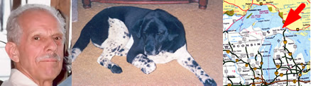
Sault Ste. Marie, MichiganTownship & County: Nearest place-name: General location: Tahquamenon Falls State Park in the eastern Upper Peninsula Trail: Victim: Joseph Robert Clewley
White male; age 73; 5'-10"; 150 lbsCase summary: Joe Clewley and his dog Chip went missing on July 13, 2008. His van was found parked at the North Country Trail (NCT) trailhead along the Tahqua Trail in the eastern reaches of Tahquamenon Falls State Park. Joe owned a log cabin in the area and enjoyed hiking off-trail in the park. SAR op mission: MiBSAR team members: Partner SAR teams & assets: SAR op results: Joe Clewley was not located Additional resources: • Learn more about this investigation
• View official, Sheriff's Office-provided Web site for victim
• View MiBSAR-provided Web site and Internet blog for victim

Friday, August 29
Reexamining the headwaters of Lynch Creek
From the North Country Trail (NCT) trailhead on the Tahqua Trail, I headed northwest on the NCT before heading due north along the buried powerline right of way, which follows the common section line between sections 7 and 12. At the point where the powerline swings to the east, I cut an azimuth due north to the main branch of Lynch Creek.
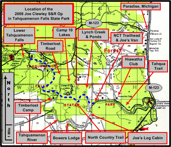
An overview of the Joe Clewley search area in the eastern Upper Peninsula of Michigan, southwest of Paradise, in the Tahquamenon Falls State Park. (Graphic by Michael Neiger)
At the Lynch, I scoured its southeast bank for any game trails that Joe may have used to cut the creek and swamp en route to the Lynch Creek Grade. I checked the few that I found upstream of the Headwaters Pond, but all petered out in the swamp opposite the creekbed turned marsh.


In the heart of the Lynch Creek Headwaters Swamp. Click on photo for high-resolution imagery. (Photo by Michael Neiger)
I did find a major game trail in the expansive marsh located in the approximate center of the Lynch Creek Headwaters Swamp. After noting its location for exploring the next day, I continued working my way east through this marsh, following a substantial game trail much of the way, until I arrived at the Section 7 Pond.


Section 7 Pond in the heart of the Lynch Creek Headwaters Swamp. Click on photo for high-resolution imagery. (Photo by Michael Neiger)
In exploring the north side of the dam impounding this waterway, I discovered a brushed-out foot trail and ATV trail. This trail—which I named the Section 7 Pond Trail—cut through a major portion of the Lynch Creek Headwaters Swamp.


Both ends of the Section 7 Pond Trail connect with the Hiawatha Hunt Club's West Bank Trail along Cheney Creek. Click on photo for high-resolution imagery. (Photo by Michael Neiger)
An old blaze in a jack pine along the Section 7 Pond Trail. Click on photo for high-resolution imagery. (Photo by Michael Neiger)
After considerable recon, I determined the trail followed a low, pine-studded ridge covered with ferns for most of its length. It appeared to start and end along the West Bank Trail, a Hiawatha Hunt Club trail that follows the west bank of Cheney Creek.

The Hiawatha Hunt Club's West Bank Trail along Cheney Creek. Click on photo for high-resolution imagery. (Photo by Michael Neiger)
After exploring this trail, I cut south from the dam to the powerline, and then cut a new route across the swamp to the Lynch Creek Headwaters Pond. Along the way, I crossed a narrow ribbon of open marsh cut by the powerline right of way.
An opening along the southern limit of the Lynch Creek Headwaters Swamp. Click on photo for high-resolution imagery. (Photo by Michael Neiger)
Arriving at sunset, I quickly set about cooking dinner before climbing in my bivy sack for the night.
Sunset over the eastern white pines surrounding the Lynch Creek Headwaters Pond. Click on photo for high-resolution imagery. (Photo by Michael Neiger)
Coyotes howled off and on through the night at various points around the compass rose. About 2:30 a.m., a brief period of high winds ushered in a bit of rain.


Saturday, August
30
Clothing fragment discovered
I climbed out of my bivy sack to find the early morning sun burning the fog off the Lynch Creek Headwaters Pond.
Morning at the Lynch Creek Headwaters Pond. Click on photo for high-resolution imagery. (Photo by Michael Neiger)
Once I'd had breakfast, I shouldered my ruck and headed east, up the headwaters marsh, to investigate the northbound game trail I had found in the open marsh located in the heart of the Lynch Creek Headwaters Swamp.


Working a faint game trail northward through the Lynch Creek Headwaters Swamp. Click on photo for high-resolution imagery. (Photo by Michael Neiger)
I worked my way north along the well-worn game trail, first through an open and expansive marsh, and then through a very tangled, seemingly never-ending swamp. With the vegetation wet from last night's rain, I was quickly soaked, but it felt good as the temperatures were climbing fast.
Eventually, I changed my northward azimuth to a westward one and arrived at the Lynch Creek Grade Pond. After scouting a slight, open rise on a peninsula jutting out from its western limit, I proceeded to recon the rather lengthy—300 meters—beaver dam impounding the pond.


The Lynch Creek Grade Pond. Click on photo for high-resolution imagery. (Photo by Michael Neiger)
From the northern end of the dam, I headed northeast to recon the remnants of the old Lynch Creek Grade as well as the ridgelines abutting it. Before long, I arrived at the Hiawatha Hunt Club's West Bank Trail.
From the western property line of the Hiawatha Hunt Club, I headed west to explore the ridgelines, two-tracks, and game trails crisscrossing Section 1, which included several private parcels, one of which was known as the old Soo Hunting Club.

A log cabin at the site of the old Soo Hunting Club in Section 1. Click on photo for high-resolution imagery. (Photo by Michael Neiger)
After 11 hours our bushwhacking with a full ruck, I ended up bivouacking on a remote ridgeline in the northern portion of Section 1, south of Lost Lake. I ate dinner in the dark, just after the sun set, accompanied by a horde of biting insects, mainly mosquitoes and no-see-ums.
While it had been a long, hard day—my 19th in search of any sign of the whereabouts of Joe—I was buoyed by the fact I had discovered the first possible sign of Joe earlier in the day: a fragmentary piece of clothing.


Sunday, August 31
Turtle shell
From my bivouac site, I worked my way southward, reconning several more ridgelines and foot-trails before passing by the Lynch Creek Grade Pond, where I found a beautiful shell from a painted turtle.


A painted turtle shell found adjacent to the Lynch Creek Grade Pond. Click on photo for high-resolution imagery. (Photo by Michael Neiger)
Sweating profusely from the heat, which would climb to around 90, I continued south to my vehicle at the NCT trailhead on the Tahqua Trail.
After a refreshing swim in the Tahquamenon River, I headed north to Paradise, Michigan where I turned the fragmentary item of evidence over to a deputy from the Chippewa County Sheriff's Office for further analysis and follow-up investigation.
Since the Joseph Clewley case is an open and active police investigation, the Sheriff's Office has requested that no further information be released about this particular piece of evidence or the circumstances surrounding how or where it was found.
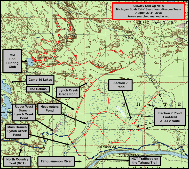
1:24,000 USGS quad showing areas searched (in red) by the Michigan Backcountry Search and Rescue Team during Clewley SAR Op No. 6, August 29-31, 2008. (Base quad with North Country Trail [NCT] plot and UTM grid overlay courtesy of Chuck McCready's No Boundaries Maps and Graphics, Inc., of Sault Ste. Marie, Michigan, an official sponsor of the Michigan Backcountry SAR Team. Annotations by Michael Neiger)


Return to top of page :: Return to home page
In God's wilderness
lies the hope of the world,
the great, fresh, unblighted,
unredeemed wilderness.
—
John Muir, 1838-1914
Alaska Wilderness, 1890
If
you've been able to read this Web page...
thank a Teacher;
If you've been able to read this Web page in English...
thank a Veteran.
—Author
unknown
•
Copyright notice •
Content Copyright © 1984 --
2009-09-16
by Michael A. Neiger
• All rights reserved •
No part of this Web page or this Web site protected by copyright law may be reproduced, transmitted, or used in any form--including graphic, electronic, Web, mechanical or other form--or by any means--including photocopying, recording, taping, Internet distribution, information storage retrieval system, or by other means--for any purpose, except by a reviewer, who may quote brief passages, without the prior, express, written permission of the author.
Comments?
Suggestions?
Dead links? Inaccurate info?
Contact the WebMaster, Michael A. Neiger, at mneiger@hotmail.com
Web site URL: www.MibSAR.com
Return to top of page :: Return to home page
You're here: MiBSAR's home page :: SAR operations log page :: SAR op photo-journal page