
You're here: MiBSAR's home page :: SAR operations log page :: SAR op photo-journal page
Michigan
Backcountry Search and Rescue (MiBSAR)
SAR Op No. 4 photo-journal:
Joe Clewley missing-person investigation
By
Michael Neiger
Marquette, Michigan
© Copyright 2008
Duration & date: Agency assisted:
_____________________
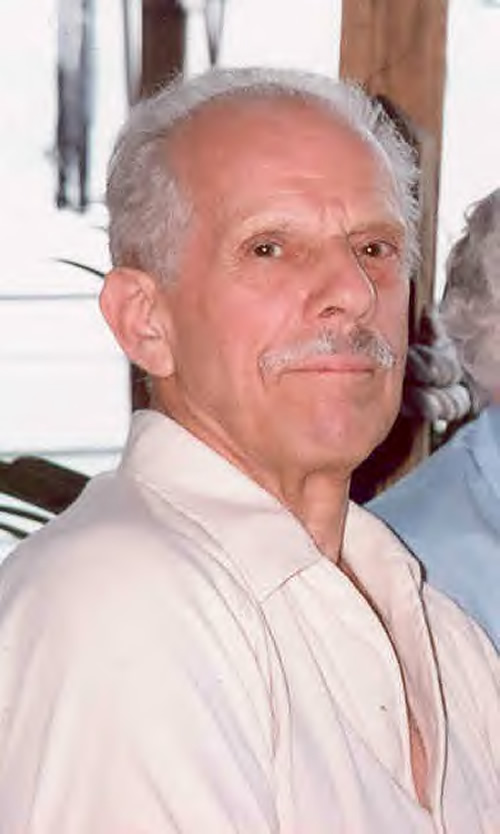
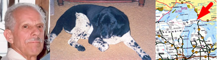
Sault Ste. Marie, MichiganTownship & County: Nearest place-name: General location: Tahquamenon Falls State Park in the eastern Upper Peninsula Trail: Victim: Joseph Robert Clewley
White male; age 73; 5'-10"; 150 lbsCase summary: Joe Clewley and his dog Chip went missing on July 13, 2008. His van was found parked at the North Country Trail (NCT) trailhead along the Tahqua Trail in the eastern reaches of Tahquamenon Falls State Park. Joe owned a log cabin in the area and enjoyed hiking off-trail in the park. SAR op mission: MiBSAR team members: Partner SAR teams & assets: SAR op results: Joe Clewley was not located Additional resources: • Learn more about this investigation
• View official, Sheriff's Office-provided Web site for victim
• View MiBSAR-provided Web site and Internet blog for victim
Friday, August 15
The Cloverland Electric Co-op powerline
search
Like the previous three Joseph Clewley SAR ops conducted by Michigan Backcountry Search and Rescue (MiBSAR), this one started out sunny and warm. SAR Op No. 4 was scheduled to be a land-based search of the upper reaches of the old Lynch Creek Grade—and adjacent ridgelines to the west—for evidence of the whereabouts of Joseph Clewley.
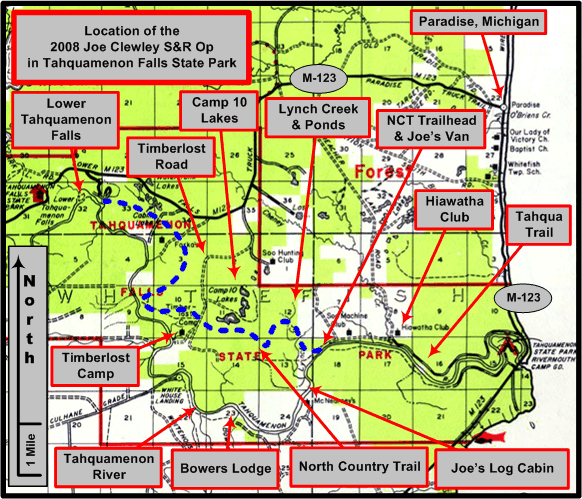
An overview of the Joe Clewley search area in the eastern Upper Peninsula of Michigan, southwest of Paradise, in the Tahquamenon Falls State Park. (Graphic by Michael Neiger)
From the North Country Trail (NCT) trailhead along the Tahqua Trail, I headed northward on the NCT until I reached the point where the trail is cut by an underground portion of the Cloverland Electric Co-op powerline running through the area.
Northbound along the North Country Trail (NCT) from the trailhead on the Tahqua Trail. (Photo by Michael Neiger)
At this point, I headed north along the powerline right of way, which appeared to run along the common section line between Sections 13 and 18.
When I reached the point where the underground powerline headed east, and turned into an aboveground system of poles and lines, I cached much of my bivouac gear in a tree to keep it safe from black bears while I searched an adjoining area.
The Cloverland Electric Co-op powerline that cuts through Joe's Country. (Photo by Michael Neiger)
I ate lunch in the shade of a jack pine, as did the black flies. The next three hours were spent searching a 150- by 200-meter area that appeared to have been previously unchecked, according to the SAR maps I had.
When this search turned up nothing but an old, white hood from a Chevrolet, I retrieved my cached gear and cut an azimuth over to the main branch of Lynch Creek, following its eastern bank upstream until I reached its headwaters pond.
Once at the headwaters pond, I crossed over the ages-old beaver dam impounding the waterway, grabbing a quart of water along the way.
Across the dam, I worked my way downstream along its western bank for several hundred meters, checking the transition line between the marsh and treeline for any sign of Joe.
Finding nothing, I cut an azimuth northward to the Lynch Creek Trail, which followed an old, logging-era railroad grade—the Lynch Grade—into the southern half of Section 6.
Northbound on Lynch Creek Trail along the remains of the old Lynch Creek Grade, just north of the North Country Trail. (Photo by Michael Neiger)
Since it was getting late, I established a night bivouac just south of The Cabins, the location where my partner, Chris Ozminski (NightBlazer), would be meeting me later in the evening.
Shortly after I had finished dinner, Chris arrived.
He had also spent some time clearing a pond located on the main branch of Lynch Creek, a few hundred meters downstream of where the NCT crossed the Lynch. From the pond, he traversed a route similar to mine to reach our bivouac site at The Cabins.
Unfortunately, he did not have any better luck than I did.
After we had both climbed in our bivy sacks for the night, we heard the raucous chatter of several coyotes about 10:45 p.m. Quickly grabbing a baseplate compass, we shot azimuths towards each coyote or group of coyotes.
The loudest—and closest—of them were situated within a few hundred meters of us along a magnetic azimuth of 025 degrees. This group was answered almost immediately by several barks from a lone coyote situated an unknown distant from us along a magnetic azimuth of 115 degrees.
All was quiet for about five minutes until we heard several barks from another lone coyote situated an unknown distance from us along a magnetic azimuth of 327 degrees. This coyote was immediately answered by a few barks from a single coyote situated very close to us along a magnetic azimuth of 025, the approximate location from which the extremely vocal howling first originated.
We carefully noted this information in a notepad so we could plot it on our quads in the morning, after which we'd definitely attempt to run down the location of the main group to see what they had been up to...


Saturday, August
16
Running down last night's howling coyotes
With the clear skies last night, I had elected to sleep out under the stars, sans tarp. However, heavy dew left me a bit damp in the morning.
After breakfast, Chris and I decided to make a single pass into the headwaters swamp that fed the main branch of Lynch Creek, before trying to chase down the location of the howling coyotes. Deep into the swamp, we emerged into a rather open area under some cedars where several game trails intersected. It was in this area that we spotted several piles of scat from passing moose, moose that would draw Joe back to this region over and over again.
After working some of these trails until they petered out, we headed for the northwest end of the dam at the headwaters pond. Before we left this area to recon the low ridge along the northwest bank of the Lynch, Chris spotted a huge eastern white pine.
Chris Ozminski (NightBlazer) next to a huge eastern white pine he spotted adjacent to the western limit of the beaver dam impounding the main branch of Lynch Creek at the headwaters pond. (Photo by Michael Neiger)
Finding no evidence of the whereabouts of Joe Clewley in this area, we cut an azimuth back to the Lynch Creek Trail and headed northward, back to our bivouac spot just south of The Cabins. Once at the cabins, we picked up our cached gear, shouldered our rucks, and headed northward along remnants of the old Lynch Creek Grade.
We hoped to locate the origin of the most raucous howling last night—that which occurred along a magnetic azimuth of 025 degrees—and see what, if anything, remained at the site.
Along the way, we reconned a low, swamp-locked ridge just west of the grade, and crossed a narrow section of swamp to recon a spur projecting out from the ridge on the opposite side of the swamp. Finding nothing in either location, we continued working our way up the old Lynch Creek Grade, all the while looking for the area where last night's howling had originated.
As Chris flanked my position along the grade proper, we cut the strong, unmistakable odor of decaying material about noon. It was so pronounced that we immediately dropped our rucks and began to search for its origin using our breeze-detecting threads.
Suspended from a branch near the pungent odor, we could watch the fine threads and easily detect the direction from which even the slightest of breezes was coming, thus allowing us to backtrack the invisible scent plume back to its origin.
After nearly two hours of work, we established that the odor was emanating from the ground a few meters east of the old grade. Unable to locate any decaying object, we surmised that whatever it was had been removed, with the odor we tracked down simply emanating from fluid that had seeped into the vegetation.
When we plotted the location of the odor on our quads, we found it was located precisely on the previous night's howling azimuth of 025. It was very possible that the coyotes had removed the decaying object responsible for the odor we smelled. We also observed a narrow line of matted grass immediately adjacent to the area from which the odor was emanating.
Unable to do much more with this lead, other than to flag it, note the wind direction (variable), and GPS it, we returned to the Clewley Cabin where we made telephone contact with Chuck McCready, a Special Deputy with the Chippewa County Sheriff's Office.
Chris Ozminski (NightBlazer) southbound on the Lynch Creek Trail to make contact with Chuck McCready, the Chippewa County Sheriff's Office SAR Boss. (Photo by Michael Neiger)
As the Sheriff's SAR Boss, he decided to return to the area in question with us. We were also accompanied by several Clewley family members and friends. Once at the site—located in the northwest quarter of the northwest quarter of Section 7, almost on the common section line between Sections 7 and 12—nearly everyone detected the strong smell of decay.
Having other areas to search before nightfall, we departed the area, knowing that Chuck would be evaluating this unusual discovery in combination with other factors to determine if it warranted further investigation, possibly by a K-9 team, perhaps even a cadaver dog.
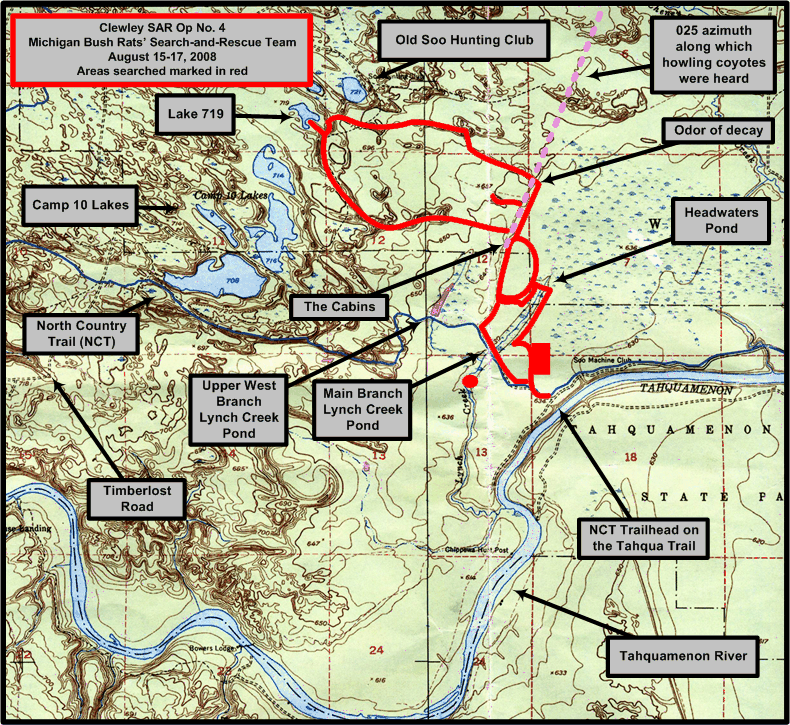
1:24,000 USGS quad showing areas searched (in red) by the Michigan Backcountry Search and Rescue Team during Clewley SAR Op No. 4, August 15-17, 2008. Click on image to view high-resolution imagery. (Graphic by Michael Neiger)
From this area—which foundation remains and a wide scattering of debris such as stoves, hinges, earthenware, metal pots, pans, iron, etc., indicated was a former railroad-era site of habitation—Chris and I bushwhacked westward along a prominent ridgeline that coursed its way near the common section line between Sections 12 and 1.
Along the way, we came upon the remains of several, old, decaying stumps from massive eastern white pines that were cut and shipped to sawmills via the old Lynch Creek Grade.
Chris Ozminski (NightBlazer) standing inside a massive eastern-white-pine stump he came across, west of the old Lynch Creek Grade in the northeast quarter of Section 12. (Photo by Michael Neiger)
Michael Neiger (LandNavMan) checking out the remains of a huge, eastern white pine, west of the old Lynch Creek Grade in the northeastern quarter of Section 12. (Photo by Chris Ozminski)
Once we'd finished reconning the above mentioned ridgelines, Chris cut an azimuth over to the Camp 10 Chain of Lakes, hoping we'd make it before dark.
Before long, we were swimming in the refreshing waters of Lake 719, which was situated in the southeast quarter of the southeast quarter of Section 2. Refreshed after a day of extreme heat, we set about brewing up hot drinks and dinner on a small, pine-studded peninsula projecting out into Lake 719.
Tired from a long day of searching, much of it with fully-loaded rucks, we climbed into our bivy sacks soon after finishing dessert, which included handfuls of humongous blueberries.


Sunday, August 17
Clearing ridgelines and cutting a nearly impenetrable swamp
Still tired from yesterday's long hike in the heat, we slept in until shortly after 7:00 a.m. We awoke to a fog-shrouded lake. Bivouacked on the tip of the peninsula like we were, the horseshoe-shaped lake nearly surrounded us with fog.
The north arm of Lake 719, part of the Camp 10 Chain of Lakes, in the southeastern quarter of Section 2, as the early-morning fog burned off. (Photo by Michael Neiger)
The south arm of Lake 719, part of the Camp 10 Chain of Lakes, in the southeastern quarter of Section 2, as the early-morning fog burned off. (Photo by Michael Neiger)
After a hearty breakfast, we shouldered our rucks and worked a series of ridgelines, first south, and then east, until we came to the headwaters swamp that fed the upper west branch of Lynch Creek.
Along the ridgelines we were treated to a couple of rare views of the Tahquamenon River Valley to the south, considering the thick canopy that shrouds much of the area.
The view of Joe's Country and the Tahquamenon River Valley from atop a high ridge in northeast quarter of Section 12, about two miles north of Joe's Chippewa Hunting Post. (Photos by Michael Neiger)
Further east along the rather remote, east-west-running ridgeline, we came upon a beautiful pocket marsh.
A remote, pocket marsh located north of a ridgeline in the center of the north half of Section 12, just west of the headwaters swamp above the upper west branch of the Lynch Creek. (Photo by Michael Neiger)
The swamp cut was one of the thickest and most difficult Chris and I had encountered since we first began searching the area. About halfway through the tangled mess, we came upon some flora struggling for footing.
Flora deep in the headwaters swamp above the upper west branch of the Lynch Creek. (Photo by Michael Neiger)
Eventually, we emerged onto the old Lynch Creek Grade, hot and sweaty. After a short break, we headed south, back to our vehicles.
Soaked with sweat and covered in dirt, we agreed we needed to swim in the Rat Hole, a swimming hole we'd discovered along the north bank of the Tahquamenon River on SAR Op No. 2.
Properly refreshed and rejuvenated, we enjoyed lunch at the restaurant located at the junction of M-28 and M-123.
Over coffee, we discussed the puzzling aspects of the Clewley investigation, knowing we would be returning to Joe's Country to continue the search to bring Joe home.


Return to top of page :: Return to home page
In God's wilderness
lies the hope of the world,
the great, fresh, unblighted,
unredeemed wilderness.
—
John Muir, 1838-1914
Alaska Wilderness, 1890
If
you've been able to read this Web page...
thank a Teacher;
If you've been able to read this Web page in English...
thank a Veteran.
—Author
unknown
•
Copyright notice •
Content Copyright © 1984 --
2009-09-16
by Michael A. Neiger
• All rights reserved •
No part of this Web page or this Web site protected by copyright law may be reproduced, transmitted, or used in any form--including graphic, electronic, Web, mechanical or other form--or by any means--including photocopying, recording, taping, Internet distribution, information storage retrieval system, or by other means--for any purpose, except by a reviewer, who may quote brief passages, without the prior, express, written permission of the author.
Comments?
Suggestions?
Dead links? Inaccurate info?
Contact the WebMaster, Michael A. Neiger, at mneiger@hotmail.com
Web site URL: www.MibSAR.com
Return to top of page :: Return to home page
You're here: MiBSAR's home page :: SAR operations log page :: SAR op photo-journal page