
You're here: MiBSAR's home page :: SAR operations log page :: SAR op photo-journal page
Michigan Backcountry Search
and Rescue (MiBSAR)
SAR Op No. 2 photo-journal:
Joe Clewley missing-person investigation
By
Michael Neiger
Marquette, Michigan
© Copyright 2008
Duration & date: Agency assisted:
_____________________
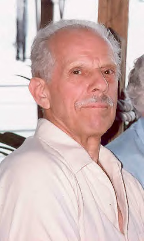
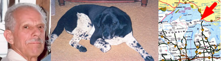
Sault Ste. Marie, MichiganTownship & County: Nearest place-name: General location: Tahquamenon Falls State Park in the eastern Upper Peninsula Trail: Victim: Joseph Robert Clewley
White male; age 73; 5'-10"; 150 lbsCase summary: Joe Clewley and his dog Chip went missing on July 13, 2008. His van was found parked at the North Country Trail (NCT) trailhead along the Tahqua Trail in the eastern reaches of Tahquamenon Falls State Park. Joe owned a log cabin in the area and enjoyed hiking off-trail in the park. SAR op mission: MiBSAR team members: Partner SAR teams & assets: SAR op results: Joe Clewley was not located Additional resources: • Learn more about this investigation
• View official, Sheriff's Office-provided Web site for victim
• View MiBSAR-provided Web site and Internet blog for victim
Friday, August 1
Backtracking Chip
With the return of Chip--Joe's faithful companion--to the Clewley cabin early this morning, I arrived to find it turned into an incident command post for the Sheriff's Office.
Joe Clewley's circa-1920, two-room, log cabin—The Chippewa Hunting Post—along the north bank of the Tahquamenon River. (Photo by Michael Neiger)
As I exited my van, I saw a half dozen or so sworn members of the Chippewa County Sheriff's Office--including Undersheriff Robert Savoie and Det./Sgt. Mike Bitnar, the lead investigator on the case--seated in a semicircle around Chip.
Chip, Joe's faithful dog, two days after his return to the Clewley Cabin. (Photo by Michael Neiger)
Having just returned from a five-mile bushwhack in which they had followed Chip in hopes he would lead them back to Joe's location, I could tell they had been working hard in the sun-baked bush for several hours.
However, everyone was still very positive and upbeat, in large part because Chip had returned, relatively unscathed after spending 20 days in the bush. We wondered aloud if he'd mixed it up with any coyotes or wolves...A day later, I would learn he was favoring an injured hip.
Russell Clewley (Joe Clewley's son), Chip, and Loraine Clewley (Joe's wife), after Chip returned to the Clewley Cabin. (Photo by Michael Neiger)
With Chip back, we decided to get our first to-scale drawing of Chip's front and rear paws for tracking purposes. To do this, we used a field-expedient technique: we wiped a front and back paw free of dirt and grime, coated them with a thin layer of hand lotion, pressed each paw onto a sheet of clean white paper placed atop a piece of plywood, poured some black fingerprint powder onto the paper, and worked the powder over the impressions with a fine brush until the paw prints became visible to the naked eye. The coal-black powder only adhered to the sticky lotion that had been transferred to the paper in the exact shape of the paw.
Chip was none too comfortable with this process, so one of us distracted/managed Chip's upper body--namely his powerful snout--while another one of us cleaned, coated, and impressed his paws on the paper.
With a high-contrast rendition of his front and rear paws in hand, we grabbed a ruler and recorded their dimensions. The front paw, the biggest of the two, measured 2.25 inches in width and 2.50 to 2.75 inches in length. The rear paw measured 2.25 inches in width and 2.25 to 2.38 inches in length.
With only one copy of the paw prints, but several teams of searchers ready to do some sign-cutting, we needed several 1:1 copies of Chip's paw prints. With the closest copy machine many, many miles away, we opted to improvise again: we'd make multiple tracings of Chip's paw prints.
Holding the sheet of paper with Chip's print on it against a car-door window backlit by the bright sun, we were able to lay a piece of paper over Chip's ink-black paw print and trace its outline. We repeated this process until we had enough copies for everyone who needed one, either for their files and for in-the-field sign-cutting ops.
With tracings of Chip's paws distributed, we set off to do some sign-cutting in hopes we could backtrack Chip's route, hopefully determining Joe's whereabouts. At the very least, we hoped to narrow down the search area, which had become overly broad, considering Joe knew the area like the back of his hand, loved to hike off trail, and was capable of trekking some 10 to 12 miles a day when he felt well.
An overview of the Joe Clewley search area in the eastern Upper Peninsula of Michigan, southwest of Paradise, in the Tahquamenon Falls State Park. (Graphic by Michael Neiger)
Our first target area was the section of the Tahqua Trail east of the Clewley Cabin that Chip had not been permitted to walk on since he had returned, from where we knew not. In short order, our sign-cutting proved fruitful: we found our first sign of Chip--a very faint, southwest-bound track--along the north edge of the Tahqua Trail, about 30 meters west of the trailhead for the North Country Trail.
The very first paw-print found that was thought to be Chip's was a faint one spotted along the north side of the Tahqua Trail, about 30 meters west of the trailhead for the North Country Trail. (Photo by Michael Neiger)
We knew this was very likely Chip's track since it matched up in all respects with the tracing we had just made of his paws. And we knew the track was made relatively recently since it had rained very hard the Tuesday night prior.
With the direction of the first track identified, some of us began methodically tracking it backwards, in the direction from which it came, using a sign-cutting or tracking stick. Such "measuring" sticks, notched with a knife to mark the stride length of the man or beast being tracked, allow a sign-cutter to quickly identify the probable location of the next unseen print based upon the location of the last known print.
The use of a sign-cutting stick proved very beneficial in picking up traces of Chip's tracks, many of which had been obliterated for long stretches by passing vehicles. At other points his tracks disappeared when he wandered into the bush, only to reappear down the trail a bit when he emerged from the bush.
While some of us methodically and painstakingly backtracked Chip's trail, paw print by paw print with a sign-cutting stick, other team members attempted to expedite the process by leaping good distances ahead to see if they could cut his track and save valuable daylight.
With good eyes and a paw tracing in hand, the forward sign-cutters had very good success. After a few hours, we had located dozens of Chip's tracks and identified their direction of travel. By plotting them on a sketch of the area, we were able to ascertain where he first stepped out of the bush and onto the Tahqua Trail.
A paw-print thought to be Chip's along the south side of the Tahqua Trail. (Photo by Michael Neiger)
With the sun about to set we met with Det. Bitnar one last time and planned out our search for the next 24 hours. Chris and I would shoulder our rucks and work a powerline and a drainage for any sign of Chip until dark, when we would bivouac. Rising early in the morning we would sweep the NCT from its trailhead on the Tahqua Trail to a set of newly-cut switchbacks on the ridge just east of chain of lakes known as the Camp 10 Lakes.
This section of trail needed to be swept (checked for evidentiary tracks) early so it was cleared for a crew of searchers who would be attempting to see if Chip would lead them anywhere useful early in the morning.
In light of our successful sign-cutting operation, Det. Bitnar was scrambling to call in other assets: hopefully one or more K-9 teams and a squad or two of searchers from the DOC's Emergency Response Team (ERT) would join us at some point during the weekend.
With our plans set, Chris and I headed into the bush to continue looking for any sign of Chip with what light remained. We followed Chip's tracks northward along an old two-track before vegetation made tracking impossible. At this point, Chris and I split up to cover more ground before dark.
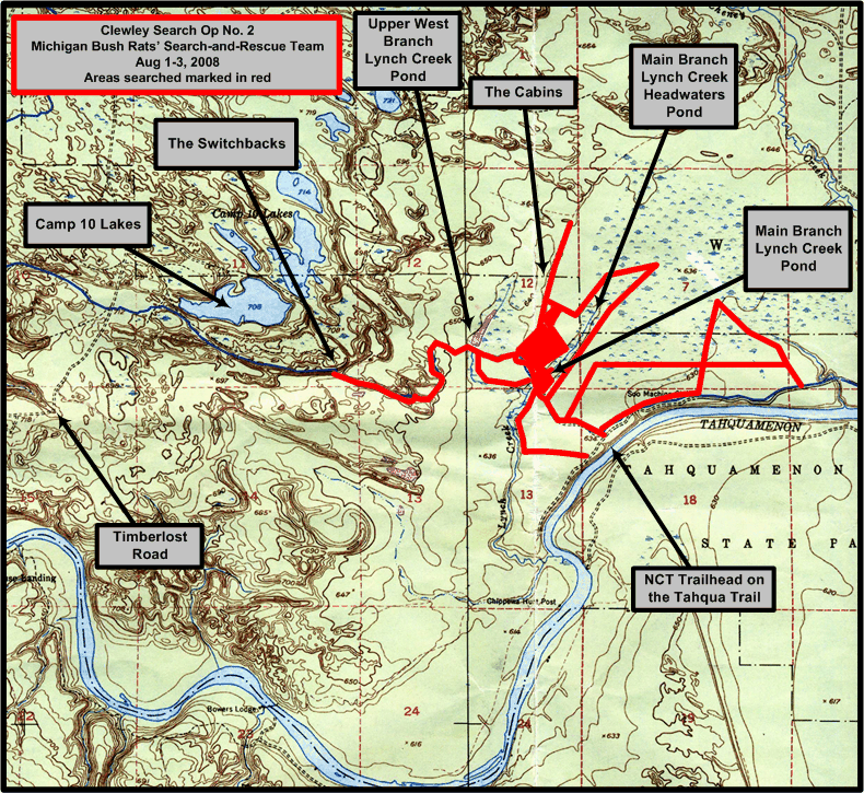
1:24,000 USGS quad showing areas searched (in red) by the Michigan Backcountry Search and Rescue Team during Clewley Search Op No. 2, August 1-3, 2008. Click on image to view high-resolution imagery. (Graphic by Michael Neiger)
Chris worked the powerline right-of-way westward while I flanked him to the north, along a drainage consisting of lowlands and several small floodings. We intended to meet up at the point where the powerline cut the North Country Trail, about halfway between the NCT trailhead on the Tahqua Trail and the NCT footbridge over the main branch of Lynch Creek.
With the light fading, Chris and I met up as planned and then headed north to Lynch Creek, where we established a hasty night bivouac, using our headlamps. While Chris had eaten earlier, I had skipped dinner due to the desire to continue the sign-cutting process before any more evidence was destroyed by rain, vehicles, or personnel. Around midnight, after I had finished dinner and we'd hung our food to protect it from roving predators--namely black bears, coyotes, and wolves--we climbed into our bivy sacks for a restful night of sleep.


Saturday, August
2
Sweeping the NCT
Chris arose at 5:30 a.m., ready for a day of intense searching. Hearing him rustling around, I decided to join him for breakfast, although I normally rise about 6:30 or so.
I'm glad Chris got us up early as it allowed us to do a detailed sweep of the NCT before the other crew arrived. After we finished clearing it around 9:00 a.m., we climbed atop a huge ridge and were able to advise Det. Bitnar via Chris' cell phone that the trail was ready for his crew.
We'd had good luck in the early-morning light too. We found our first sign of Chip, a single track hidden in mud beneath tall grass, immediately north of the NCT foot bridge over the main branch of Lynch Creek, which was located in the southeast quarter of the southeast quarter of section 12.
In a sandy, eroded area just a bit down the NCT from the muddy track, we were able to determine that Chip had been milling around on the trail, just as if he had stepped out on the trail after walking some distance in the bush. From this point, we tracked him on and off before we saw our last sign of him--two toe prints--going up the switchbacks.
Chris Ozminski uses a sign-cutting (or tracking) stick to find the next probable location of Chip's paw print, as measured from a prior known print (not visible in picture), on the North Country Trail, west of the Lynch Creek Floodings. Chris has notched the stick at the average length of Chip's stride to assist him in finding subsequent tracks that are too faint to see at first. For comparison purposes, an exact, to-scale tracing (not visible in photo) of Chip's paw on a piece of white paper is situated adjacent to the paw print in question. (Photos by Michael Neiger)


With our assigned section of the trail cleared, and Det. Bitnar notified of same, Chris and I struck off for our second objective of the day: to recon the headwaters of the main branch of Lynch Creek for any north-south-running moose trails that Joe reportedly frequented in search of moose.
As we worked our way up the beautiful, pine-studded, relatively-low ridge flanking the south side of Lynch Creek, Chris, working point as he often does, spotted a single Canidae-family track in a small muddy spot that was all but hidden from view by tall grass.
By comparing and contrasting the track with the outline, pad configuration, length, and width of the tracing we'd made of Chip's track, we were able to conclude with a good degree of certainty that Chip had passed by this point since the last rain fell.
Unfortunately, thick ground cover prevented us from picking up any more sign of Chip.
As we neared the height of land between the Lynch Creek watershed and another, unnamed watershed, we came to a beautiful pond, one that must draw Joe back to area over and over again. Near the head of the pond we paused to inspect an excellent, old-growth specimen--a giant eastern white pine. Beyond it, to the east, was an expansive marsh and bog.
Chris Ozminski pauses at the base of a massive eastern white pine situated along a foot trail near the Lynch Creek headwaters pond in the northwest quarter of section 7. (Photo by Michael Neiger)
Once we'd checked the height-of-land area fairly well, we cut northeast across the boggy area to reach the north bank of the Lynch Creek drainage.
We then headed downstream to recon the old beaver dam that created the headwaters pond. We wanted to see if there was any of sign of Joe cutting across it. Atop the dam, but beneath several ages-old northern white cedars that shaded us from the hot sun, we enjoyed lunch and refilled our water bottles.
The Lynch Creek headwaters pond in the northwest quarter of section 7. (Photos by Michael Neiger)
With lunch over, we continued hiking northward until we cut the old Lynch Creek Trail, a favorite trekking corridor of Joe's. Arriving late in the afternoon, we cached much of our bivouac gear and rations in a tall tree before reconning the area. Just north of our cache, we ran across "The Cabins," a rather intriguing opening in the forest that was littered with the ruins of several wood-framed buildings. It must have been quite the place in its day, and we could see why Joe spoke of it often and fondly.
Chris Ozminski surveys the ruins of "The Cabins" along the Lynch Creek Trail in the northeast quarter of section 12. (Photo by Michael Neiger)
We worked the trail a bit further north into the swamp before meeting up with Joe Jr., his friend Scott, and a K-9 team from Bay Mills. After chatting with them near the end of a small ridge jutting up out the wet swamp, we headed back south to recon an area bounded on the north by a section of lowlands just south of The Cabins, on the south by the NCT, on the west by the Lynch Creek Trail, and on the east by Lynch Creek. Along the way we caught a glimpse of a ruffed grouse, apparently a mother trying to lure us away from its young.
A ruffed grouse in Joe's Country, southeast of the "The Cabins" along the Lynch Creek Trail in the northeast quarter of section 12. (Photo by Michael Neiger)
After searching the area with repeated, parallel passes, northward from the NCT, and failing to turn up any sign of Joe or Chip, we headed north to establish our night bivouac just south of The Cabins. With dinner down, we chatted awhile before turning in early. It had been a long, hard day of bushwhacking, much of it under the blistering sun.


Sunday, August 3
Up close and personal in Lynch Creek
Pond
Tired from nearly 10 hours of searching the previous day, we both slept in until nearly 7:00 a.m.
Once back at the trailhead to dump off some our unneeded bivouac gear, we ran into the DOC's ERT crew, which was in the process of assembling for a day of searching itself. Minutes later, Det. Bitnar arrived and said we should all assemble down at the incident command post--the Clewley Cabin--for a meeting.
After the meeting, at which I chatted with a Michigan State Police K-9 handler with whom I had worked prior cases with, we returned to the trailhead and stashed most of our bivouac gear so we could travel light and fast. Our rucks reconfigured to carry just our survival gear, foul-weather clothing, and a day's rations, we immediately headed for the footbridge over the main branch of Lynch Creek.
The beaver pond located along the North Country Trail on the main branch of Lynch Creek, in the southeast quarter of section 12. (Photo by Michael Neiger)
Once at the creek, Chris and I each jumped into the knee- to waste-deep swamp slop. A barely-floating bog at some points, we worked our way upstream through the marsh grass along the immediate south and north flanks of the creek channel until we reached the point where the creek was impassable due to interwoven vegetation. We then proceeded to check both margins of the marsh at the treeline, working our way downstream to the NCT, where we had started.
Chris Ozminski searches the flooded marsh along the south bank of the the main branch of Lynch Creek, in the southeast quarter of section 12, north of the North Country Trail. (Photos by Michael Neiger)
Before we departed the area, Chris volunteered to strip to his swim trunks and dive under the bridge as well as work the bottom of the pond proper. Despite repeated dives, complete with risky, appendage probes between submerged bridge pilings and old deck timbers, he did not turn up any evidence of Joe's whereabouts.
Chris Ozminski searching under the upstream side of the North Country Trail foot bridge over the main branch of Lynch Creek in the southeast quarter of section 12. (Photos by Michael Neiger)
When Chris emerged from the swampy water after checking the downstream side of the bridge, two leeches--including one, giant, four-inch-long one--lost their grip on his skin and fell to the bridge decking!
His careful probing of the main pond did not produce any results either.
Chris Ozminski searches the muddy bottom of the pond located just north of the North Country Trail on the main branch of Lynch Creek in the southeast quarter of section 12. (Photo by Michael Neiger)
Shouldering our rucks, we decided to search the forested north bank of the main branch of Lynch Creek down to its confluence with the upper west branch of the Lynch. Once at the west branch, we headed upstream along its south bank, eventually coming to the NCT bridge over this waterway. Here we took a break in the shade of some overhanging tag alders. Eventually Det. Bitnar and the ERT crew passed by on their way back to the trailhead. They too did not have anything to report.
The beaver pond located along the North Country Trail on the upper west branch of Lynch Creek, in the southeast quarter of section 12. (Photo by Michael Neiger)
A short time after they departed, we were confronted by a rather gruff character who, after inquiring if we were part of the search party, more or less demanded we tell him what we knew about the case. Not sure what his relationship was to Joe or how he fit into Det. Bitnar's protracted investigation, we basically told him the whole case was one big question mark to us. We then stepped around him on the narrow boardwalk and headed for our next search area, the low ridge forming the southern bank of the main branch of the Lynch, downstream of the NCT bridge.
This area did not reveal any clues either. We did find one ground blind, two tree blinds, and two, cartilage-attached bones--one of which had been cut completely through. The bones, which may have been from a white-tailed deer, may well have been carried to the area by a coyote, possibly from a poacher's kill site.
Before we departed for home, Chris and I reconned the north bank of the Tahquamenon River for a good swimming hole. We found it on our third try. It was one we figure Joe loves too: a beautiful, pine-studded bank looking down over an unimpeded waterway. After taking in the view, we scrambled down the bank and dove into the refreshing water, some of which had coursed through Joe's Country, miles upstream.
After about ten minutes of relaxing swimming, we figured we'd rinse off most of the grime and swamp water we'd accumulated from three days of off-trail work.
While we did not find any sign of Joe's whereabouts yet, we departed Joe's Country in good spirits knowing Chip had returned to the safety of his caring family and that we'd had the good fortune to backtrack him for several kilometers, which would help us reenergize and refocus our search efforts on future ops.
Joseph Clewley has been missing near the North Country Trail, south of Paradise, Michigan, since July 12, 2008. (Photo courtesy of the Chippewa County Sheriff's Office.)
As we were drying off, Chris and I formulated a tentative plan to return for another 3-day, land-based search from August 15th to the 17th. This one would see us returning to a high-probability search area straddling the upper reaches of the Lynch Creek Trail, one in which the Bay Mills K-9 handler had told us his dog had "hit" on some scent on a prior search....


Return to top of page :: Return to home page
In God's wilderness
lies the hope of the world,
the great, fresh, unblighted,
unredeemed wilderness.
—
John Muir, 1838-1914
Alaska Wilderness, 1890
If
you've been able to read this Web page...
thank a Teacher;
If you've been able to read this Web page in English...
thank a Veteran.
—Author
unknown
•
Copyright notice •
Content Copyright © 1984 --
2009-09-16
by Michael A. Neiger
• All rights reserved •
No part of this Web page or this Web site protected by copyright law may be reproduced, transmitted, or used in any form--including graphic, electronic, Web, mechanical or other form--or by any means--including photocopying, recording, taping, Internet distribution, information storage retrieval system, or by other means--for any purpose, except by a reviewer, who may quote brief passages, without the prior, express, written permission of the author.
Comments?
Suggestions?
Dead links? Inaccurate info?
Contact the WebMaster, Michael A. Neiger, at mneiger@hotmail.com
Web site URL: www.MibSAR.com
Return to top of page :: Return to home page
You're here: MiBSAR's home page :: SAR operations log page :: SAR op photo-journal page